A Smarter Approach to Managing Vessels, Assets, and Offshore Activities
A Smarter Approach to Managing Vessels, Assets, and Offshore Activities
Maritime operations are often influenced by conditions that can shift unexpectedly. A clear day can rapidly turn into poor visibility, changing weather patterns, or nighttime circumstances that make even familiar tasks more demanding. In these moments, the biggest challenge is frequently not the marine environment itself but the absence of timely and dependable information. When critical updates are spread across multiple systems and teams are forced to work with fragmented data, overall awareness declines. As a result, communication becomes less effective, decision-making slows, and risks to people, assets, and essential operations increase.
ToolKitX helps organizations overcome these challenges by delivering a centralized platform for managing maritime activities. Built as a cloud-based solution, it provides continuous oversight, real-time operational visibility, and a shared view of ongoing activities within a single connected environment. Instead of depending on separate applications and disconnected data sources, organizations involved in port management, offshore wind operations, marine logistics, coastal projects, and energy-related marine activities can work from one synchronized operational picture. This consolidated approach improves decision-making speed, minimizes uncertainty, and enables teams to act with confidence based on reliable information.
Functioning as a modern operational hub for maritime activities, ToolKitX offers a structured and comprehensive view of vessels, offshore assets, and coastal operations. Data collected from AIS, ADS-B, GPS, radar, and other available tracking technologies is brought together and displayed through integrated nautical mapping. This creates a live operational view that remains clear, accurate, and easy to understand. Rather than burdening users with excessive information, the platform applies intelligent filtering and rules-based processing to ensure attention is directed toward the events and conditions that truly require action.
By identifying potential concerns early, organizations can address issues before they develop into larger operational challenges. Whether a vessel approaches a restricted area, assets move too close together, speed limits are exceeded, or routes diverge from approved plans, ToolKitX detects these situations in real time. Early visibility allows teams to coordinate more effectively, communicate more efficiently, and respond before minor deviations become significant incidents. Because all stakeholders rely on the same trusted information source, misunderstandings are reduced and operational responses become more streamlined.
Near real-time location updates provide a clear picture of vessel position, movement, speed, direction, and operational status through an interactive map available to both offshore and onshore teams. A key feature of the platform is its sophisticated geofencing capability. Virtual boundaries can be established around ports, offshore facilities, wind farms, exclusion areas, and environmentally sensitive locations. Once these zones are configured, the platform continuously evaluates activity against predefined operational rules. If a vessel enters a restricted area, exceeds speed limits, violates timing requirements, or crosses a designated boundary without authorization, automated response workflows are immediately triggered through targeted alerts.
Alerts can be delivered through desktop applications, mobile devices, email, or integrated systems, ensuring that important information reaches the appropriate personnel regardless of where they are located. Notifications are assigned according to defined roles and responsibilities so that only relevant individuals receive them. This focused distribution approach helps reduce unnecessary interruptions and minimizes alert fatigue. In addition to live monitoring, ToolKitX maintains a complete historical record of operational activity. Vessel movements, alerts, events, and behavioral patterns are securely stored, providing a dependable source of information for audits, investigations, insurance reviews, compliance requirements, and internal evaluations.
Key Capabilities
Continuous Tracking and Historical Replay
Teams can oversee large operational regions or concentrate on individual vessel activity as needed. Historical replay functionality, available for periods of up to 90 days, includes route and speed data that support operational reviews, compliance verification, incident analysis, and near-miss investigations.
Intelligent Rules-Based Geofencing
Geofencing capabilities extend beyond simple location boundaries. Organizations can create rules that include speed limits, time-sensitive conditions, proximity thresholds, and combinations of multiple operational criteria. Notifications are automatically routed to the appropriate parties, including HSE personnel, contractors, and regulators, improving oversight while limiting unnecessary alerts.
Integrated Weather Awareness
Environmental conditions such as sea state and wind speed can be monitored alongside established operational limits. This allows decision-makers to evaluate whether offshore activities, personnel transfers, or other high-risk operations should continue, pause, or be rescheduled based on current conditions.
Proactive Collision Risk Detection
A built-in CPA engine supports the early identification of potential collision scenarios before they become critical. These events are logged and monitored, creating a structured process for review and contributing to continuous improvements in safety performance.
Unified Asset and Workforce Management
ToolKitX maintains organized records for vessels, aviation assets, operational equipment, and crew certification requirements. Automated notifications help organizations remain compliant and operationally prepared without relying on manual tracking processes.
Mobile Support for Remote Operations
Designed for practical use in field environments, the mobile application remains effective even when connectivity is limited. Remote personnel can review alerts, access recent position information, and manage geofencing activities while operating away from central locations.
Why Organizations Choose ToolKitX
Many organizations adopt ToolKitX to replace disconnected systems with a single, reliable source of operational truth. By consolidating information from AIS, radar, GPS, and ADS-B into one environment, marine operations teams, logistics departments, and HSE professionals gain a consistent understanding of current activities. Immediate notifications for unauthorized zone entries, speed violations, and CPA-related concerns help reduce operational risks, protect critical assets, prevent disruptions, and support business continuity.
The platform also streamlines compliance and reporting processes. Comprehensive activity records, export-ready reports, and structured audit trails simplify investigations and regulatory assessments. Whether supporting a small fleet or overseeing complex multi-asset marine operations, ToolKitX scales to match organizational needs while providing controlled access for different user groups.
· Security and compliance are integrated throughout the platform. Every movement, alert, and user action is recorded, while encryption safeguards data during both transmission and storage. Before deployment, organizations can model operational scenarios involving shipping routes, harbors, offshore wind developments, and transit corridors. This enables workflows and rules to be refined in advance, ensuring the platform is aligned with real operational requirements from the very beginning.
Book a free demo @ https://toolkitx.com/campaign/gps-tracking/
Browse More
https://toolkitx.com/campaign/meeting-room/
https://toolkitx.com/campaign/communication/
Categories
Read More
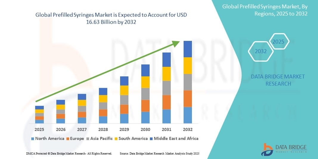
Prefilled Syringes Market According to the latest report published by Data Bridge Market Research, the Prefilled Syringes Market The global prefilled syringes market size was valued at USD 8.04 billion in 2024 and is expected to reach USD 16.63 billion by 2032, at a CAGR of 9.50% during the forecast period An excellent Prefilled Syringes...
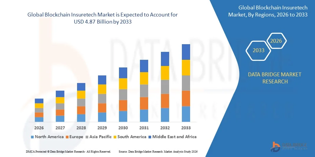
Blockchain Insuretech Market: According to the latest report published by Data Bridge Market Research, the Blockchain Insuretech Market The global blockchain insuretech market size was valued at USD 2.20 billion in 2025 and is expected to reach USD 4.87 billion by 2033, at a CAGR of10.40% during the forecast period Attaining maximum return on...
Buy Instagram Accounts Bulk Are you looking to enhance your social media presence and reach a wider audience on Instagram? The process of growing an Instagram account organically can be time-consuming and challenging. However, there is a solution that offers a shortcut to success - buying Instagram accounts in bulk. In this article, we will delve into the world of purchasing Instagram accounts...